Watching the Lava dome: Volcano monitoring radar handover to Montserrat
![]() Dr David Macfarlane is a Senior Research Fellow who has been working on high resolution radar projects in the School of Physics and Astronomy at St Andrews since 2002. Last year he travelled to the volcanic island of Montserrat to hand over operation of the All-weather Volcano Topography Imaging Sensor (AVTIS) to the Montserrat Volcano Observatory (MVO).
Dr David Macfarlane is a Senior Research Fellow who has been working on high resolution radar projects in the School of Physics and Astronomy at St Andrews since 2002. Last year he travelled to the volcanic island of Montserrat to hand over operation of the All-weather Volcano Topography Imaging Sensor (AVTIS) to the Montserrat Volcano Observatory (MVO).
The AVTIS radar was a research instrument specifically developed as a remote sensing tool for monitoring the changing shape of volcanic lava domes through conditions of obscured visibility. It can ‘see’ through cloud and ash to make 3D maps and images of the volcano surface to measure any changes in shape when lava is extruded. The original lava dome test case for AVTIS was the Soufrière Hills Volcano on the island of Montserrat, a British dependency, which is monitored by a dedicated observatory (MVO). With the radar proven in the field, funding from the EPSRC Impact Acceleration Account over the last four years has allowed Dr Macfarlane to work with MVO to refurbish the AVTIS remote site and upgrade the system for routine operational use by MVO scientists.
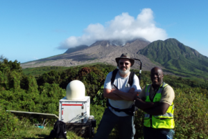
In March of 2019 AVTIS was officially handed over to MVO. Dr Macfarlane explains: “The AVTIS radar instrument was originally a research instrument that required a radar expert to operate it. The upgrades we have made to the hardware and the controlling software have been designed under close collaboration with MVO scientists and staff so that it is easy to control and can now run automatically to scan the mountain around the clock. AVTIS will now provide data that will be of real use to MVO in their task of providing hazard analysis of lava dome activity for the people of Montserrat. This is a unique instrument that gives MVO a capability that no other volcano observatory in the world has: being able to see through the cloud to monitor the volcano directly.”
In addition to providing 3D maps of the volcanic lava dome, IAA funding also enabled the addition of a high resolution radar rainfall mapping mode. This is intended to help with understanding how flash floods, known as lahars, occur on the flanks of the volcano. Using this rainfall data, MVO wanted to develop improved hazard warning for the catchment areas which have suffered from flash flooding and lahars and which threaten local residents, the sand mining industry and tourism relating to the volcano.
The official handover of AVTIS operation was a part of a trip to deliver the final training for MVO staff alongside a new AVTIS instruction manual and technical documentation. Dr Macfarlane also presented MVO with a poster showing the history use of AVTIS in Montserrat for the MVO research gallery.